The archaeological and historical heritage of Alugolle pitiya
.png)
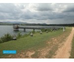
Division : Alugolle pitiya River Basin : Gampaha Specified Extend : Attanagaluoya Acs Actual Extend : Acs Capacity : 203 Acft Coordinates : L2/10.10x6.10) Farm Families :
| Nearest Land Mark : | - |
|---|---|
| How to reach : | - |
| Division : | Alugolle pitiya |
| River Basin : | Gampaha |
| Specified Extend : | Attanagaluoya Acs |
| Actual Extend : | Acs |
| Acft Coordinates : | L2/10.10x6.10 |
| Farm Families : | - |
| Museum type : | - |
| Build on : | - |
| Build By: | - |
| Managed By : | - |
| Purpose : | - |
| Area(ha): | |
| Capacity: | 203 |
| Full Supply level(mMSL) : | - |
| High flood level(mMSL) : | - |
| [email protected](ha) : | |
| Description : | - |
| Historical Value: | - |
| Any other important details: | - |

.png)


No discussions found!